Decode it: METARs, NOTAMs & sectional charts
The three skills a text question can only half-teach. Read a weather report, a NOTAM, and a VFR sectional the way the test expects — then drill them. 14 CFR 107.49 (preflight)
1 · Decode a METAR
A METAR is an observed weather report. Read it left to right. Example:
KORD 121651Z 18012G20KT 10SM FEW050 27/14 A2998 RMK AO2
| group | means | how to read it |
|---|---|---|
| KORD | Station | Reporting station — ICAO identifier (here, Chicago O’Hare). |
| 121651Z | Date/time | Day 12 of the month, 1651 UTC ("Z" = Zulu / UTC). Always UTC, not local. |
| 18012G20KT | Wind | From 180° true at 12 knots, gusting 20 kt. "VRB" = variable; "00000KT" = calm. Gusts matter for control margin. |
| 10SM | Visibility | Statute miles. Part 107 requires at least 3 SM from the control station. Fractions like "1/2SM" appear in low vis. |
| FEW050 | Sky / clouds | Few clouds at 5,000 ft AGL. SKC/CLR = clear · FEW (1–2/8) · SCT (3–4/8) · BKN (5–7/8) · OVC (8/8). A "ceiling" is the lowest BKN or OVC layer. |
| 27/14 | Temp / dew point | Temperature 27°C / dew point 14°C. A small, closing spread → fog/low cloud risk. Drives density altitude too. |
| A2998 | Altimeter | Altimeter setting 29.98 inHg. |
| RMK … | Remarks | Automated/manual notes (e.g., AO2, sea-level pressure). "AUTO" earlier in the report = automated station. |
For Part 107: you need at least 3 SM visibility and must stay 500 ft below / 2,000 ft horizontally from clouds. Watch wind & gusts for control, and a closing temp/dew-point spread for fog. 14 CFR 107.51 · AIM 7-1
2 · Read a NOTAM
A NOTAM (Notice to Air Missions) flags a temporary change you must know before flying — closed runways, new obstacles, airspace restrictions, and TFRs (issued as FDC NOTAMs).
Check before every flight: the FAA NOTAM Search (notams.aim.faa.gov), your B4UFLY-style app, or a Flight Service briefing (1-800-WX-BRIEF). A TFR — common over wildfires, stadiums, and VIP movements — can ground you even in otherwise-legal airspace. 14 CFR 107.49 · 107.45 (TFRs)
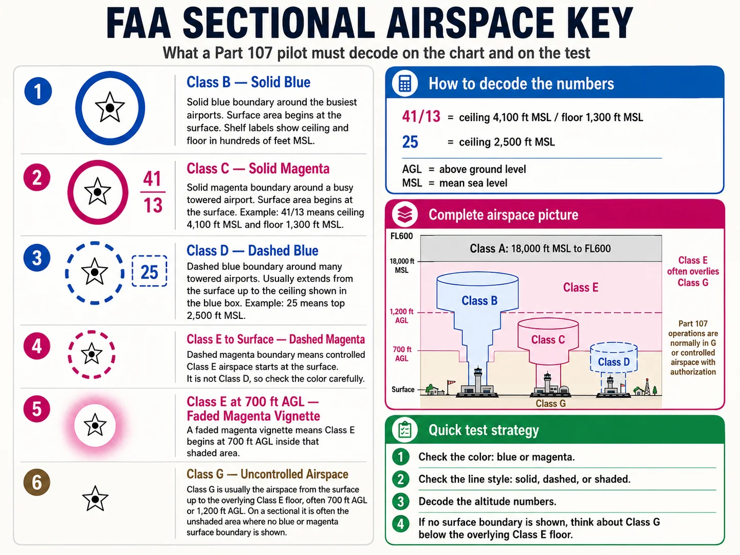
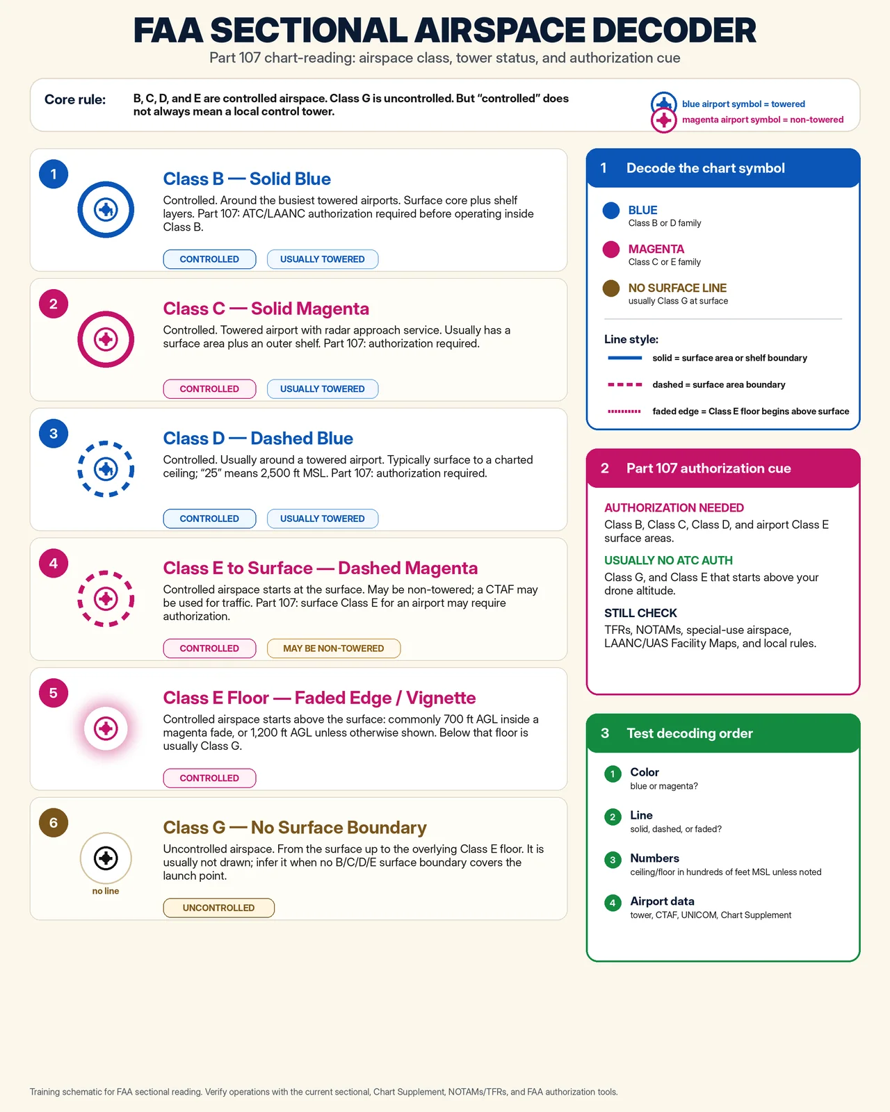
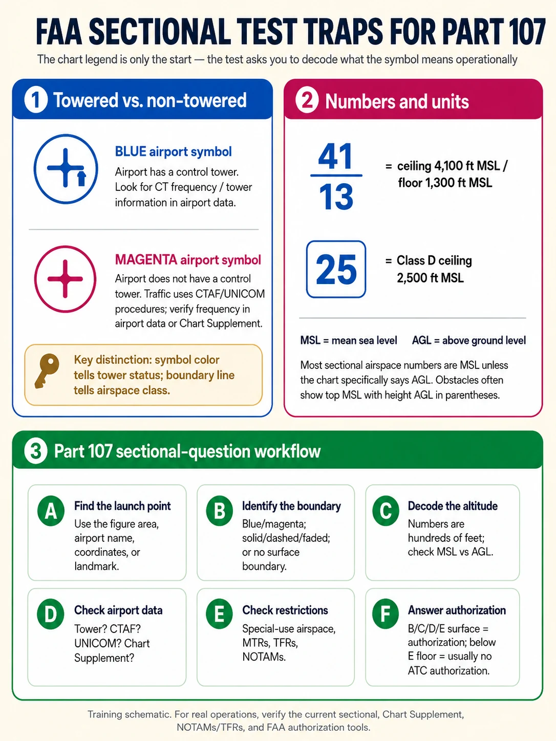
3 · Read a VFR sectional chart
The exam shows cropped chart excerpts and asks what airspace you’re in and how high it goes. The color and line style tell you the class; the numbers give ceilings/floors in hundreds of feet MSL.
| airspace / symbol | how it’s drawn | what it tells you |
|---|---|---|
| Class B | Solid blue lines | Concentric rings ("upside-down wedding cake"). Floors/ceilings printed in blue (e.g., 100/SFC = 10,000 ceiling / surface floor, in hundreds of ft MSL). |
| Class C | Solid magenta lines | Ceiling/floor in magenta, e.g., 41/13 = 4,100 MSL ceiling over 1,300 MSL floor. |
| Class D | Dashed blue lines | Ceiling shown in a dashed blue box, e.g., [25] = 2,500 ft MSL (top of Class D). |
| Class E to the surface | Dashed magenta line | Encircles an airport where controlled airspace reaches the ground. |
| Class E from 700 AGL | Faded magenta vignette | Shaded magenta band that fades outward — Class E floor begins at 700 ft AGL inside it. |
| Class E from 1,200 AGL | Faded blue vignette / boundary | Outside the magenta — controlled Class E begins at 1,200 ft AGL. |
| Class G | No outline (uncontrolled) | Everything below the Class E floor. No ATC authorization needed, but other rules still apply. |
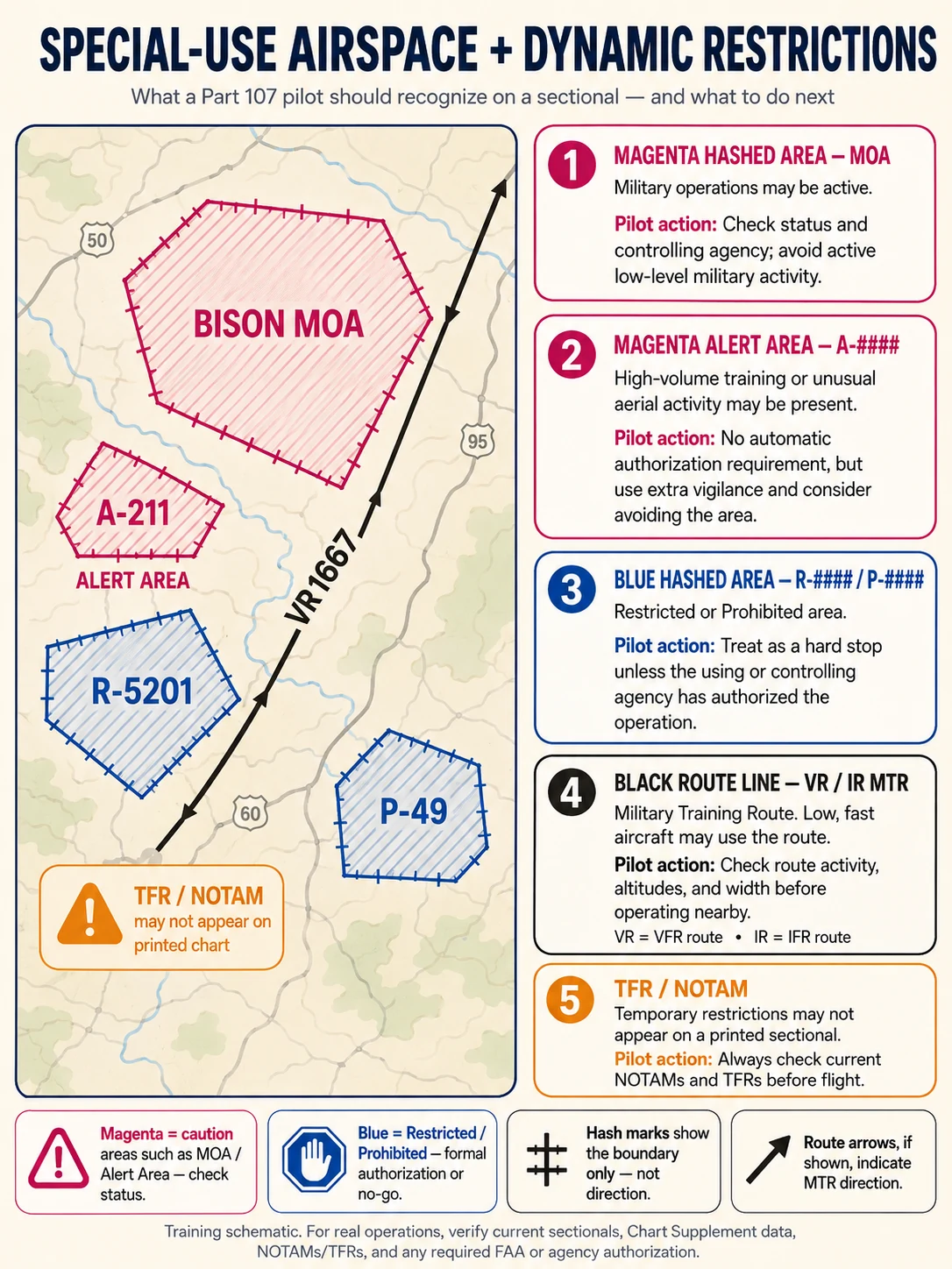
| MOA / Alert / Warning | Magenta hatched border | Special-use airspace; check times of use. |
| Restricted / Prohibited | Blue hatched border (R-### / P-###) | Do not enter Prohibited; Restricted only when "cold"/authorized. |
| MEF (Max Elevation Figure) | Large bold number in a quadrangle | e.g., 12⁵ = 12,500 ft — highest terrain/obstacle in that quadrangle. |
| Latitude / longitude | Thin black tick lines | Latitude lines run east–west and measure north/south position. |
Rule of thumb: blue = Class B & D, magenta = Class C & E; solid = B/C, dashed = D and surface-E, faded vignette = where Class E begins aloft. Controlled airspace (B/C/D/surface-E) needs prior ATC authorization — get it instantly via LAANC. 14 CFR 107.41 · Sectional Chart legend
Sectional decoder cheat-sheets
Five one-page references for reading the chart the way the test asks. Tap any sheet to open it full-size.
Independent study aid — always verify operations against the current sectional, Chart Supplement, and NOTAMs/TFRs.
4 · Read airport markings & the traffic pattern
You won’t land at an airport, but the exam tests airport markings — and knowing them helps you predict where manned aircraft will be so you can stay clear.
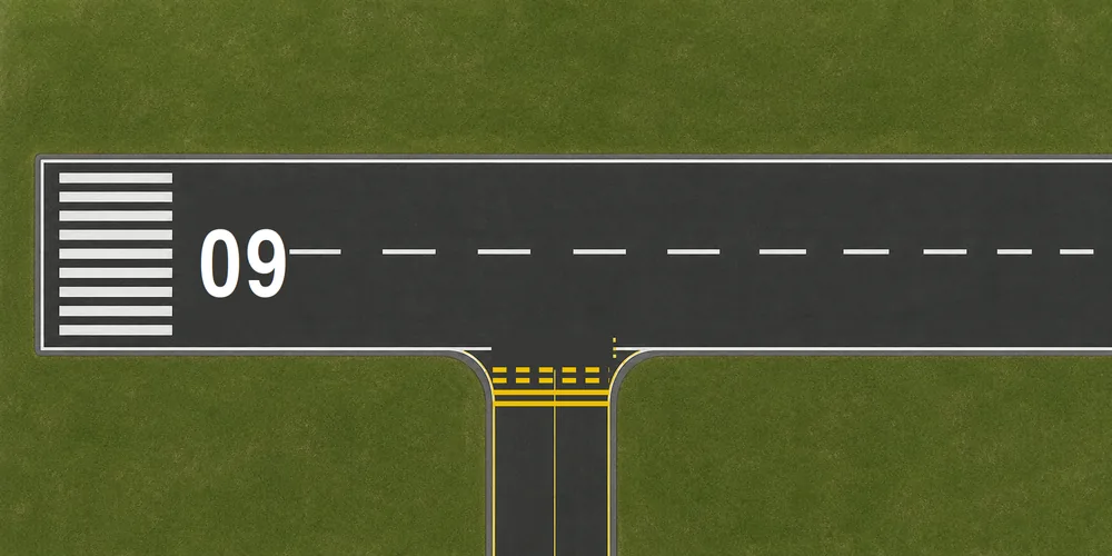
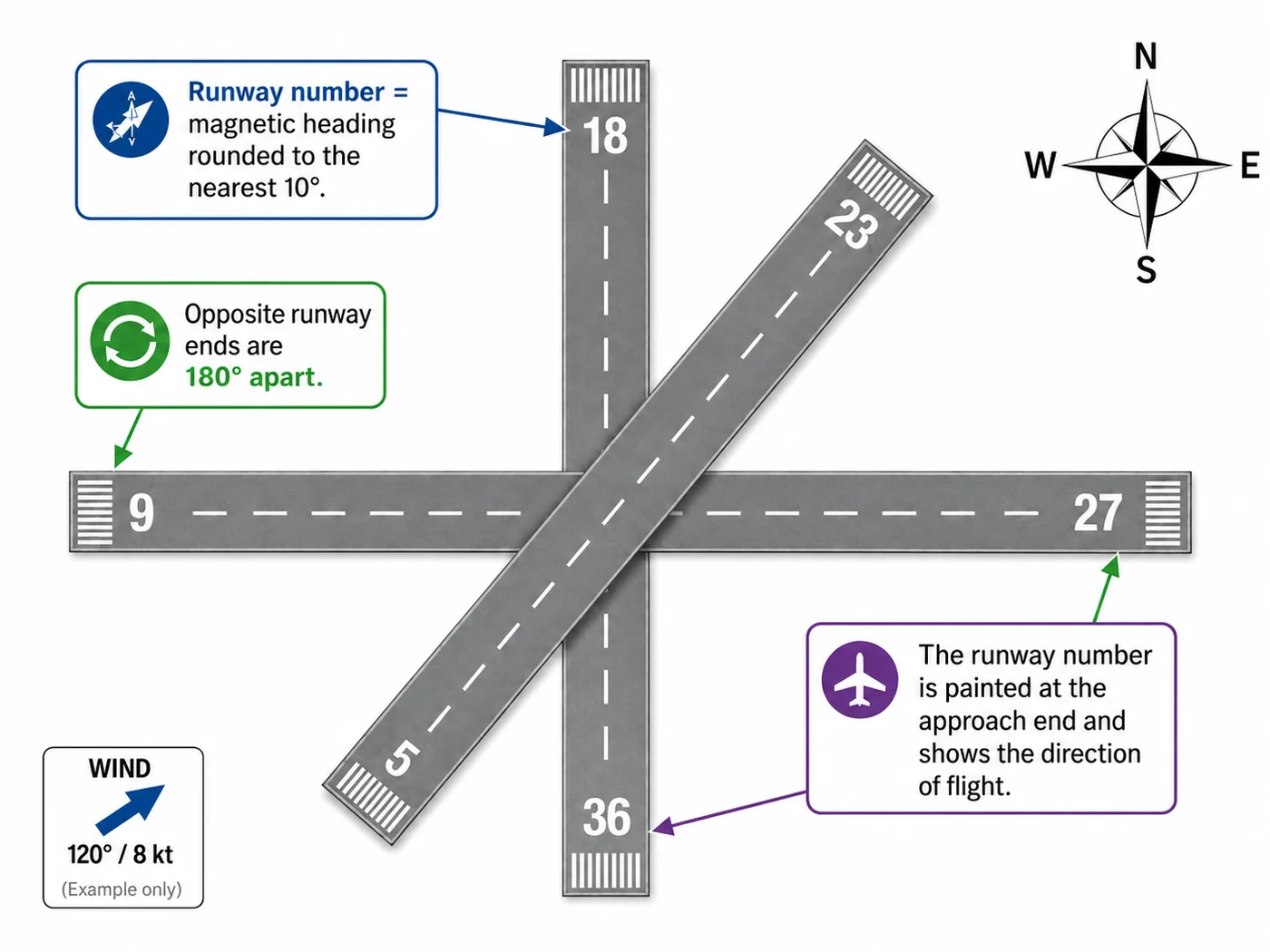
- Runway numbers = magnetic heading ÷ 10. Runway “09” points ~090°; the other end is “27” (270°) — always 18 apart.
- Hold-short marking = two solid + two dashed yellow lines. Hold short of the solid side; don’t cross onto the runway until cleared (towered) or confirmed safe (non-towered).
- Displaced threshold (arrows → a solid line) = pavement usable for taxi/takeoff but not landing.
- Traffic pattern = left turns by default; pilots self-announce on the CTAF at non-towered fields.
FAA-H-8083-25C Ch.14 · AIM 2-3 / 4-1 / 4-3
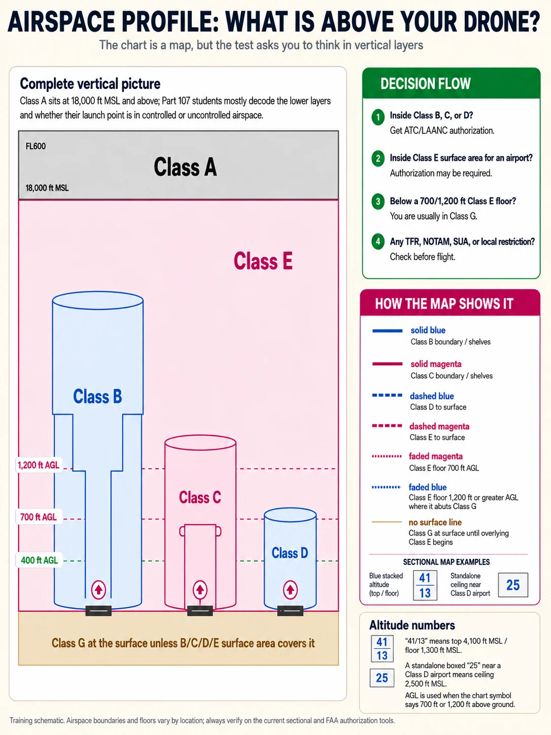
5 · The airspace cross-section
A sectional is the top-down view; this is the side view of the same airspace. Most Part 107 flying starts in Class G (uncontrolled), below the Class E floor.
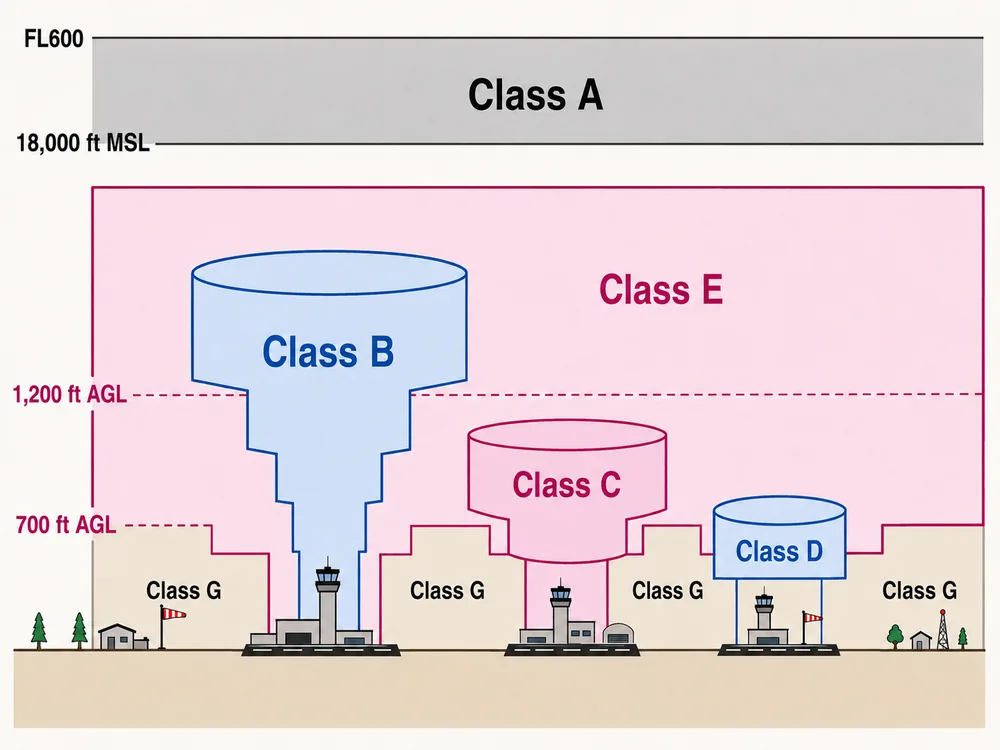
Class A: 18,000′ MSL→FL600 (drones never go there). Class B/C/D surround busy airports and need ATC authorization. Class E is controlled airspace that begins at 700′ or 1,200′ AGL (or the surface near some airports); everything below it is Class G. AIM 3-2 / 3-3
Checkride107 is independent prep — not affiliated with or endorsed by the FAA. Always verify against the current FAR/AIM and chart legend.